Posts

Showing posts with the label civil engineering

Steel Reinforcement : Understanding the Basics

 Reinforcement of Steel: Understanding the Basics Introduction: The use of steel in construction has become extremely popular due to its strength and durability. Reinforcement of steel is an essential process that involves strengthening and supporting structures to ensure their safety and longevity. The primary objective of reinforcing steel is to enhance the load-bearing capacity of a structure and to ensure that it can withstand harsh external conditions. What is Reinforcement of Steel? Reinforcement of steel, also known as rebar, is a process that involves adding steel bars or mesh to concrete structures to support them. The purpose of reinforcement is to enhance the strength and durability of a structure, making it resistant to stresses such as tension, compression, bending, shear, and torsion. Reinforcement also helps to prevent cracking, which can weaken concrete structures over time. Types of Reinforcement: There are two types of reinforcement used in construction: primary a...
What is RCC Culvert and its Drawing?

Image
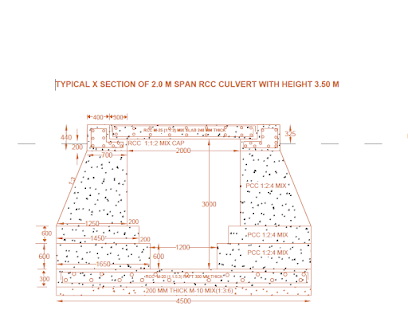
  Reinforced cement concrete Culvert is used as a Cross Drainage component in Road Construction. Culvert is mainly used to make way for an existing natural water source or other water body beneath the road. As the name suggests RCC means culvert having steel reinforcement.  In this photo RCC culvert with a span of 2 meter and height of 3.50 meter is shown. Culverts are important in the same way as are bridges . Culverts are used as cross drainage components.

Breast Wall

Image
Breast wall  are types of protection walls used in civil engineering  works. Breast  are used to  protect  the fresh cut of earth. There  is always a confusion between  retaining wall and breast wall. The Breast  wall is built on the  hill side  of a  Road as it  protects the natural cut slope of Road. Retaining wall  is built on the valley side  of road. Breast has a small range of height nearly from 2 to 3 meters and retaining wall can  have more height.  Breast   wall  help  in  protecting  the cut  slope from further Erosion.  Both breast walls and Retaining walls  are used in hilly road constructions  having steep slopes and it can  also be used  in Embankment to protect them from erosion. Breast wall can be constructed in plain  Concrete or in Stone Masonry. In these photos we  can see Breast walls being constructed in Stone masonry ...

GABION CRATES OR WIRE CRATES.

Image
  GABION CRATES OR WIRE CRATE ARE ALSO USED AS A PROTECTION WORK FOR PROTECTING LARGE MASSES OF EARTH. THEY CAN BE USED AS RETAINING AS WELL AS BREAST WALL. WIRE CRATES ARE AVAILABLE IN DIFFERENT SIZES AS PER THE SITE REQUIREMENTS. WIRE CRATES ARE MOSTLY ZINC COATED SO THAT RUST DOESNOT AFFECT THEM. WIRE CRATES ARE EASY TO LAY AND EFFECTIVE IN WORK. STONES ARE PACKED IN LAYERS IN WIRE CRATES AND WHICH IS EVENTUALLY LOCKED BHY JOINING WIRES MAKING IT AS A COMPLETE STRUCTURE.

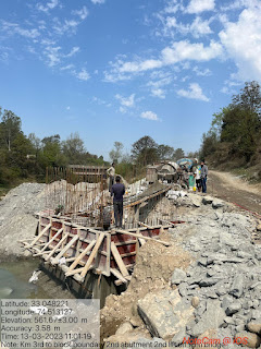
Bridge Abutment:- it is substructure part of bridge which supports superstructure. Abutment are reinforced structure and are constructed in high strength Concrete Mix Design. Formwork should be proper so that no leaking on concrete takes place .

Image
  It is substructure part of bridge which supports superstructure.  Abutment are reinforced structure and are constructed in high strength Concrete Mix Design. Formwork should be proper so that no leaking on concrete takes place . Bridges are very important part of modern fast moving life providing better connectivity across different regions. Being a very important aspect of engineering proper care should be taken while constructing such structure.

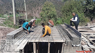
REINFORCED CEMENT CONCRETE CULVERTS.:- IT IS A TYPE OF CROSS DRAINAGE STRUCTURE AS THE NAME SUGGEST IT IS REINFORCED STRUCTURE. IT CONSISTS OF CONCRETE ABUTMENTS AND RCC CAP ON TOP WHERE RCC SLAB IS LAID. Reinforcement is provided in cap as well as slab. Abutments transfer the moving or passing vehicle load to the soil.

Image
 

BREAST WALLS:- BREAST walls are provided to hold in place mass of earth or excavation. They provide stability to natural slope. In these photos walls are being provided in dry stone masonry with rRandom Rubble masonry in 1:6 mix cement sand mortar in vertical bands and concrete in bottom .

Image
BREAST walls are provided to hold in place  mass of earth or excavation. They provide stability to natural slope. In these photos  walls are being provided in dry  stone masonry with Random Rubble masonry in 1:6  mix cement sand mortar in vertical bands and concrete in bottom. At some places breast wall in concrete are also provided with proper weep holes to drainage out the water.   

Earthwork in cutting for construction of Road. Earth excavation machines are used to cut the earth and level them or fill pits with earth material.

Image
 

WATER LOGGING

Image
WATER LOGGING  is one of the major problems of land degradation in India. Unscientific management of soil, water and crops in irrigated lands and obstruction of natural drainage systems by various developmental activities are the main factors responsible for disrupting the balance of inflow and outflow of water, leading to water logging. While irrigation has increased by leaps and bounds, its attendant problem of water logging is now plaguing substantial area of agricultural lands . An irrigated area is said to  be waterlogged when the surplus water stagnates due to poor drainage or when the shallow water table rises to an extent that soil pores in the root zone of a crop become saturated, resulting in restriction of the normal circulation of the air, decline in the level of oxygen and increase in the level of carbon dioxide. The actual depth of water table, when it starts affecting the yield of the crops adversely, may vary over a wide range from zero for r...

Irrigation channel...

Image
An irrigation channel is a conduit that transports wat   Irrigation is an artificial application of water to the soil. It is usually used to assist the growing of crops in dry areas and during periods of inadequate rainfall. Irrigation is an artificial application of water to the soil. It is usually used to assist the growing of crops in dry areas and during periods of inadequate rainfall. Water is important in every aspect of life whether it is farming or any daily life need. Irrigation canal is life life on farming. With the help of irrigation canal the water is transported from one place to another place of requirement with ease and efficiency.

Types of Dams

Types of Dams:   Dams can be grouped according to the type of material of which they are constructed as follows; concrete dams are further grouped according to how they achieve their strength and stability.  CONCRETE DAMS Concrete Gravity Dams Concrete Arch Dams Concrete Buttress Dams FILL (EMBANKMENT) DAMS Earth Dams Earth and Rock Fill Dams Concrete Faced Rock Fill Dams Concrete Gravity Dams rely on the weight of the concrete of which they are built to resist the forces (gravity, water pressure, earthquake) to which they are subjected. Concrete Arch Dams and Buttress Dams can be built using a smaller amount of concrete than that required for a Gravity Dam and, as a result, are cheaper to build. This is possible because Arch and Buttress Dams are designed to transfer some of the loads (forces) on them to the foundation on which they are built ie the strength of the foundation is used to help resist the loads which could not be resisted simply by ...

ndian pattern tangent clinometer

Image
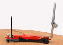
Indian pattern tangent clinometer  is used for determining differnce in elevation between two points and is specially adopted to a plane tabling. The clinometer is placed on table which is levelled by estimation. Clinometer consists of following parts: 1.A base plate 2.The eye vane 3.The object vane

DAMS

  dam  is a barrier that impound water  or underground streams. Dams generally serve the primary purpose of retaining water, while other structures such as f loodgates  or levees  (also known as  d ikes ) are used to manage or prevent water flow into specific land regions.Hydropower  and  p umped storage  electricity   are often used in conjunction with dams to generate electricity. A dam can also be used to collect water or for storage of water which can be evenly distributed between locations.

Raft foundation

RAFT FOUNDATION IS A  thick concrete slab resting on a large area of soil/surface reinforced with steel, supporting column or wall and transfer its  loads from the structure to  soil. it is generally used to support structures like residential or commercial buildings, hostel/schools  where soil condition is poor, storage tanks, silos, foundations for heavy industrial equipment etc. it is very important type of foundation in modern ways of construction.

Sprinkler irrigation system.

Image
Sprinkler Irrigation is a method of applying irrigation water which is similar to rainfall. Water is distributed through a system of pipes usually by pumping. It is then sprayed into the air and irrigated entire soil surface through spray heads so that it breaks up into small water drops which fall to the ground . Sprinklers provide efficient coverage for small to large areas and are suitable for use on all types of properties. It is also adaptable to nearly all irrigable soils since sprinklers are available in a wide range of discharge capacity.

what is Prismatic compass ?

Image
Compass surveying is a branch of surveying in which directions of surveying lines are determined with a compass and the length of lines are measured with a tape or chain. In practice the compass is  generally used to run a traverse. In surveying, "Traverse" consists of a series of straight lines connected together to form a open or a closed polygon. Methods of traversing: Depending on the type of instrument used for the measurement of angles the method of Traversing can be classified as under; 1.Chain Traverse 2.Compass Traverse. 3.Plane Table Traverse. 4.Stadia Traverse. 5.Theodolite Traverse. IN Compass Traverse the direction of the traverse lines are determined with a magnetic compass. The magnetic Compass may be "SURVEYOR COMPASS" OR "PRISMATIC COMPASS" PRISMATIC COMPASS: The prismatic compass is one of the magnetic compass in which there is a prism for taking observations. The prismatic compass is generally smaller in size than a surveyor  compass. T...

what is contouring?

Image
A contour is defined as an imaginary line of constant elevation on the ground surface. It can also be defined as the line of intersection of a level surface with the ground surface. For example, the line of intersection of the water surface of a still lake or pond with the surrounding ground represents a contour line.                                                                                                   It facilitates depiction of the relief of terrain in a two dimensional plan or map. The process of tracing contour lines on the surface of earth is called contouring. A contour map gives the idea of the altitudes of the surface features as well as their relative positions in a plan CONTOURING BY INDIRECT METHOD: The points surveyed...

what is chain survey.......

Image
Chain survey is the simplest method of surveying. In this survey only measurements are taken in the field, and the rest work, such as plotting calculation etc. are done in the office. This is most suitable adapted to small plane areas with very few details. If carefully done, it gives quite accurate results. The necessary requirements for field work are chain, tape, ranging rod, arrows and some time cross staff. Survey Station: Survey stations are of two kinds Main Stations Subsidiary or tie Main Stations: Main stations are the end of the lines, which command the boundaries of the survey, and the lines joining the main stations re called the main survey line or the chain lines. Subsidiary or the tie stations: Subsidiary or the tie stations are the point selected on the main survey lines, where it is necessary to locate the interior detail such as fences, hedges, building etc. Tie or subsidiary lines: A tie line joints two fixed points on the main survey lines. It helps to checking the ...

plane table survey................

Image
Plane table is a graphical method of surveying in which the field works and the plotting is done simultaneously. It is particularly adopting in small mapping. Plane table surveying is used for locating the field computation of area of field. Merits: It is most suitable for preparing small scale map or surveying small area. It is most rapid method. Field book is not necessary. No great skill is required for satisfactory map. It is particularly suitable for magnetic area where prismatic compass is not reliable. Contour and irregular object may be represented accurately. It is less costly. Demerits: Plane Table Essentially a tropical instruments. It is not suitable to work in wet climate. There are several accessories to be carried out and therefore they are likely to be lost. It is not suitable for accurate work. Parts of plane Table: Plane table essentially consist of Drawing board mounted on tripod. Alidade.

Gunter's chain......

it is a measuring device used for land survey. Gunter divided the chain into 100 links, marked off into groups of 10 by brass rings which simplified intermediate measurement. On the face of it, the dimensions make no sense: Each link is 7.92 inches long; 10 links make slightly less than 6 feet 8 inches and a full length of 66 feet. In fact, he had made a brilliant synthesis of two incompatible systems, the traditional English land measurements, based on the number 4, and the newly introduced system of decimals based on the number 10.