Posts

Showing posts with the label prismatic compass

Steel Reinforcement : Understanding the Basics

 Reinforcement of Steel: Understanding the Basics Introduction: The use of steel in construction has become extremely popular due to its strength and durability. Reinforcement of steel is an essential process that involves strengthening and supporting structures to ensure their safety and longevity. The primary objective of reinforcing steel is to enhance the load-bearing capacity of a structure and to ensure that it can withstand harsh external conditions. What is Reinforcement of Steel? Reinforcement of steel, also known as rebar, is a process that involves adding steel bars or mesh to concrete structures to support them. The purpose of reinforcement is to enhance the strength and durability of a structure, making it resistant to stresses such as tension, compression, bending, shear, and torsion. Reinforcement also helps to prevent cracking, which can weaken concrete structures over time. Types of Reinforcement: There are two types of reinforcement used in construction: primary a...

what is Prismatic compass ?

Image
Compass surveying is a branch of surveying in which directions of surveying lines are determined with a compass and the length of lines are measured with a tape or chain. In practice the compass is  generally used to run a traverse. In surveying, "Traverse" consists of a series of straight lines connected together to form a open or a closed polygon. Methods of traversing: Depending on the type of instrument used for the measurement of angles the method of Traversing can be classified as under; 1.Chain Traverse 2.Compass Traverse. 3.Plane Table Traverse. 4.Stadia Traverse. 5.Theodolite Traverse. IN Compass Traverse the direction of the traverse lines are determined with a magnetic compass. The magnetic Compass may be "SURVEYOR COMPASS" OR "PRISMATIC COMPASS" PRISMATIC COMPASS: The prismatic compass is one of the magnetic compass in which there is a prism for taking observations. The prismatic compass is generally smaller in size than a surveyor  compass. T...

what is chain survey.......

Image
Chain survey is the simplest method of surveying. In this survey only measurements are taken in the field, and the rest work, such as plotting calculation etc. are done in the office. This is most suitable adapted to small plane areas with very few details. If carefully done, it gives quite accurate results. The necessary requirements for field work are chain, tape, ranging rod, arrows and some time cross staff. Survey Station: Survey stations are of two kinds Main Stations Subsidiary or tie Main Stations: Main stations are the end of the lines, which command the boundaries of the survey, and the lines joining the main stations re called the main survey line or the chain lines. Subsidiary or the tie stations: Subsidiary or the tie stations are the point selected on the main survey lines, where it is necessary to locate the interior detail such as fences, hedges, building etc. Tie or subsidiary lines: A tie line joints two fixed points on the main survey lines. It helps to checking the ...

Gunter's chain......

it is a measuring device used for land survey. Gunter divided the chain into 100 links, marked off into groups of 10 by brass rings which simplified intermediate measurement. On the face of it, the dimensions make no sense: Each link is 7.92 inches long; 10 links make slightly less than 6 feet 8 inches and a full length of 66 feet. In fact, he had made a brilliant synthesis of two incompatible systems, the traditional English land measurements, based on the number 4, and the newly introduced system of decimals based on the number 10.

dumpy level........

Image
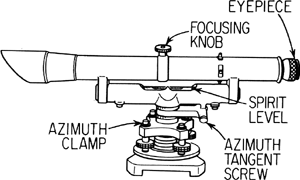
A surveyor instrument having a short telescope fixed rigidtly to a horizontal rotating table.