Posts

Showing posts with the label Contour

Steel Reinforcement : Understanding the Basics

 Reinforcement of Steel: Understanding the Basics Introduction: The use of steel in construction has become extremely popular due to its strength and durability. Reinforcement of steel is an essential process that involves strengthening and supporting structures to ensure their safety and longevity. The primary objective of reinforcing steel is to enhance the load-bearing capacity of a structure and to ensure that it can withstand harsh external conditions. What is Reinforcement of Steel? Reinforcement of steel, also known as rebar, is a process that involves adding steel bars or mesh to concrete structures to support them. The purpose of reinforcement is to enhance the strength and durability of a structure, making it resistant to stresses such as tension, compression, bending, shear, and torsion. Reinforcement also helps to prevent cracking, which can weaken concrete structures over time. Types of Reinforcement: There are two types of reinforcement used in construction: primary a...

ndian pattern tangent clinometer

Image
Indian pattern tangent clinometer  is used for determining differnce in elevation between two points and is specially adopted to a plane tabling. The clinometer is placed on table which is levelled by estimation. Clinometer consists of following parts: 1.A base plate 2.The eye vane 3.The object vane

what is contouring?

Image
A contour is defined as an imaginary line of constant elevation on the ground surface. It can also be defined as the line of intersection of a level surface with the ground surface. For example, the line of intersection of the water surface of a still lake or pond with the surrounding ground represents a contour line.                                                                                                   It facilitates depiction of the relief of terrain in a two dimensional plan or map. The process of tracing contour lines on the surface of earth is called contouring. A contour map gives the idea of the altitudes of the surface features as well as their relative positions in a plan CONTOURING BY INDIRECT METHOD: The points surveyed...

what is chain survey.......

Image
Chain survey is the simplest method of surveying. In this survey only measurements are taken in the field, and the rest work, such as plotting calculation etc. are done in the office. This is most suitable adapted to small plane areas with very few details. If carefully done, it gives quite accurate results. The necessary requirements for field work are chain, tape, ranging rod, arrows and some time cross staff. Survey Station: Survey stations are of two kinds Main Stations Subsidiary or tie Main Stations: Main stations are the end of the lines, which command the boundaries of the survey, and the lines joining the main stations re called the main survey line or the chain lines. Subsidiary or the tie stations: Subsidiary or the tie stations are the point selected on the main survey lines, where it is necessary to locate the interior detail such as fences, hedges, building etc. Tie or subsidiary lines: A tie line joints two fixed points on the main survey lines. It helps to checking the ...

dumpy level........

Image
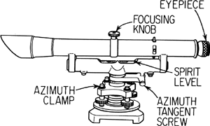
A surveyor instrument having a short telescope fixed rigidtly to a horizontal rotating table.